News - Construction News
Drone developed for Fukushima
Radiation levels over Fukushima can now be tested, thanks to a new drone developed in the UK via NDA R&D funds.
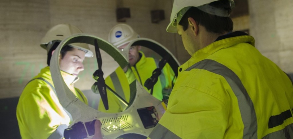
The lightweight RISER drone has been developed by two UK businesses to help investigate hazardous environments where GPS signals cannot reach, it has already been trialled successfully at Sellafield where it has been collecting vital information about the remaining Windscale Pile chimney. More than 60 years after the 1957 fire, the chimney remains highly contaminated.
The drone uses lasers to self-navigate and carries a sophisticated radiation detection and mapping system. Due to the hazardous nature of the building, remotely operated equipment is the only way to establish how the chimney can be cleaned out and finally dismantled.
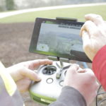
RISER – Remote Intelligence Survey Equipment for Radiation – combines two separate pieces of cutting-edge technology: drones and radiation-mapping software. Each received Research and Development funding through the NDA and fellow government agency, Innovate UK.
The first technology, Createc’s N-VisageTM radiation mapping software project, was developed in 2009 and received £50,000 investment from the NDA’s R&D portfolio.
In 2012, a number of government organisations decided to invest further funds in a wide range of innovative nuclear projects. This led to the collaboration between Cockermouth-based Createc and aerial systems specialist Blue Bear, from Bedford and the creation of the RISER drone. After a series of on-site trials at Sellafield, RISER was put into decommissioning action.
The NDA’s Head of Technology, Prof Melanie Brownridge, said: “We are thrilled to see RISER put to work in Japan, and delighted that our early-stage support for the N-Visage system enabled Createc to develop its potential further.
“The subsequent collaboration with Blue Bear, again funded by the NDA through an initiative with Innovate UK, led to RISER. This shows the importance of funding innovative ideas through their journey from the drawing board to the market – not just for the NDA’s decommissioning mission but for the wider UK and overseas economy.”
The N-VisageTM tailor-made technology maps radiation with pinpoint accuracy, producing a high-definition 3D picture of contamination, quickly and safely. The technology was first used inside one of the reactor buildings at Japan’s Fukushima-Daiichi plant several years ago, the collaboration has allowed it to be combined with a drone.
The drone, or unmanned aerial vehicle (UAV), is less than one metre in diameter and navigates using its own internal ‘collision avoidance’ capability. Able to manoeuvre accurately inside complex industrial spaces, data is transmitted to the mapping system and clearly displayed, highlighting areas of contamination.
If you would like to read more articles like this then please click here.


More News
- Development partner sought for Broad Marsh regeneration
5 Jun 26
Homes England has officially initiated a search for a master development partner for the former
- Regional funding to train next generation of construction workers
4 Jun 26
£96 million investment directly addressing the structural skills deficit within the UK construction sector.
- New report finds increase in tender workload, but projects are failing to reach site
3 Jun 26
The latest industry report by the Southern Construction Framework (SCF) identifies a complex landscape for